The HorizontAR feature allows you to view peak names and their elevations directly in the field using augmented reality on your mobile device. With this feature, you can easily identify which peaks you see on the horizon around you. This function is available to premium users and can be used to explore surroundings all around the world.
If you don’t have an active Premium subscription or a trial version, you can try this feature as part of a preview – up to 5 times for free without a subscription.
How to use HorizontAR
You can find the HorizontAR feature in the main menu of the Mapy.com mobile app.
- When you launch it for the first time, you’ll need to allow the app access to the camera and location (if not already enabled).
- An augmented reality viewer will open using your phone’s camera.
- Point the phone so the camera faces the horizon (as if you were photographing the distant landscape).
- The app will load data for your current position in the background.
- You’ll be asked to manually align a guide line with the horizon seen through your camera – you can move the line with one finger, rotate or zoom using two fingers.
- Your manual calibration is saved and will be used automatically next time.
- By pressing the curved arrow in the top right corner, you will reset the settings.

An internet connection is required to use HorizontAR.
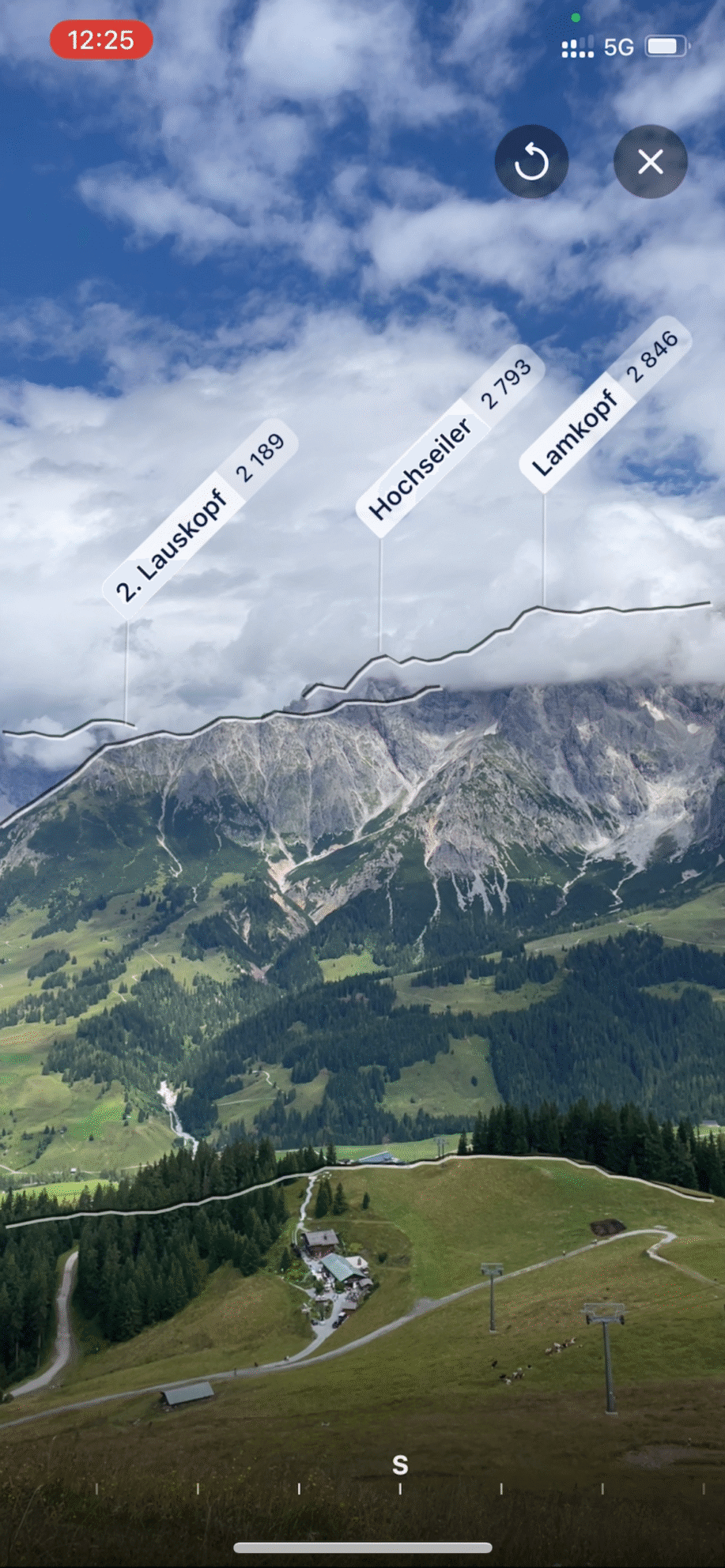
Each identified peak will display its name and elevation. At the bottom of the screen, there’s a transparent bar with compass directions (e.g. N, NE, SW) to help you orient yourself. You can turn around or tilt your phone up and down to see peak names around you. HorizontAR works in both portrait and landscape mode – just rotate your phone.
For each identified peak, you can see its name and, by default, its elevation in meters above sea level. By tapping on the peak label, you can switch the displayed value to the distance to the peak in kilometers. This change applies to all displayed peaks. Tapping again will switch the display back to elevation.
You can also easily take a photo of the current horizon and save it to your gallery or share it. Tap the camera button located at the bottom of the screen. In the generated preview, you can further adjust the position and orientation of the horizon using gestures. Then choose “Save” to store the photo in your phone’s gallery, or select the share button and choose the app you want to use to share the generated image.
The HorizontAR feature can be used in both landscape and portrait modes—simply rotate your phone.
Didn’t find your answer?
Check out what people are saying in the forum. They share their questions, tips, and experiences to make Mapy.com even better.