When planning a route using public transport, you can adjust the departure or arrival time and set the desired date and time (e.g., 17:15). If you leave the option “today, now” selected, the current date and time will be used. Clicking in the field will display a clear calendar where you can set any date and time.
Timetables are obtained directly from transport providers, and their availability depends on mutual agreements. Currently, it is possible to search for connections throughout the Czech Republic. After entering the starting point and destination, the route is automatically calculated. The found connections are displayed in separate blocks in the right-hand side panel, listed one below the other. The first found connection is shown on the map.
You can view earlier or later connections by clicking the “previous connection” or “next connection” links in the right panel.

The offered results are for informational purposes only. Although we strive to display the most up-to-date data, actual conditions may vary depending on the transport provider or unexpected events.
Route Planning
Route planning for public transport works similarly to other types of transportation, with a few specific differences and it is available only online. When planning, you enter the Start, Destination, and any via points (there is no limit to the number of via points). You can also adjust the date and time of arrival or departure. If you leave the option “today, now” selected, the current date and time will be used.
After entering the details, a chronological list of connections to the selected destination will be displayed. Each connection consists of one or more lines (routes). If needed, you can click on Previous to view earlier connections.
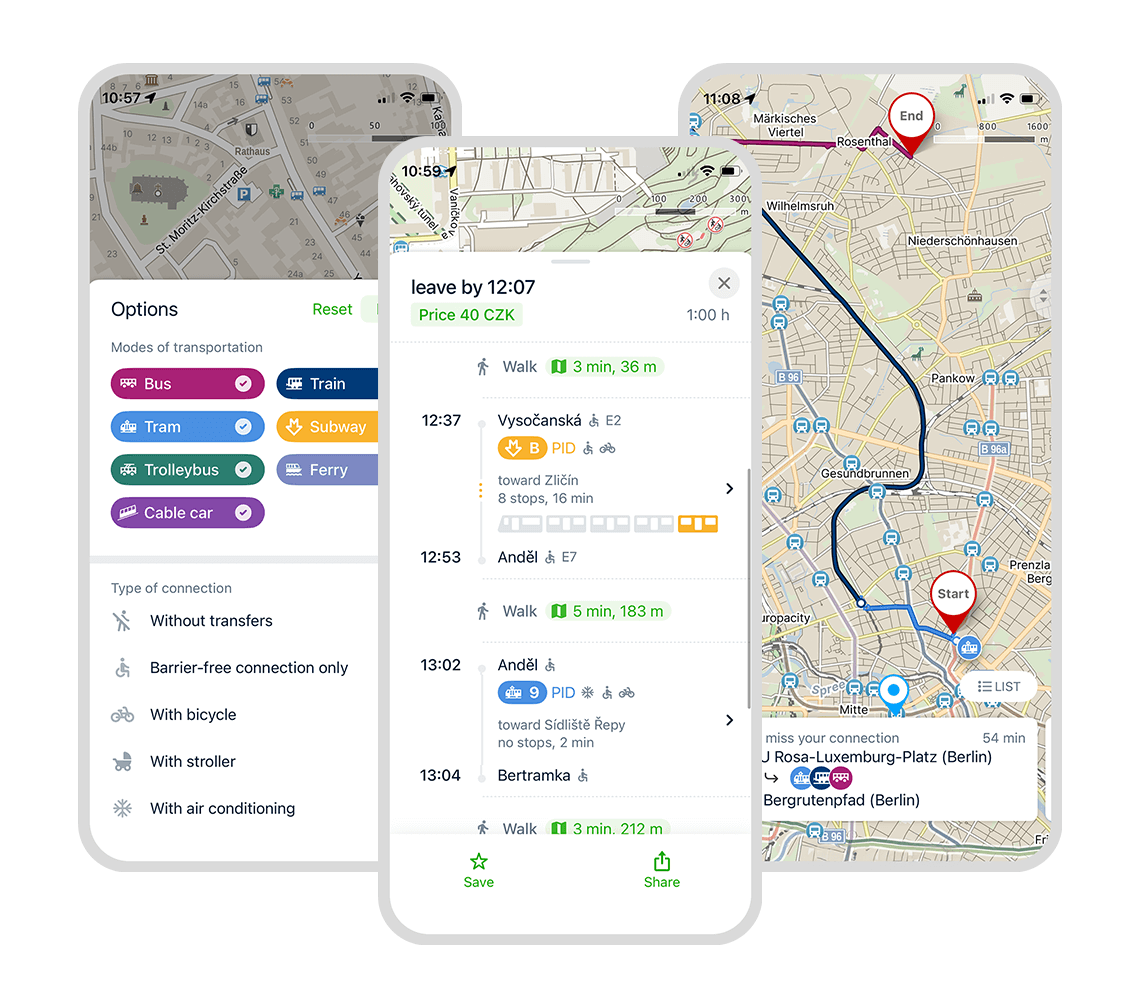
Options
In the route planning options, you will find additional route settings. From the available modes of transport, you can choose which ones to include:
- Bus
- Train
- Tram
- Underground
- Trolleybus
- Ferry
- Cable car
Underground lines are shown on the map in their actual colours, e.g. Prague’s line A – green, etc. If we do not have data about the colours of underground lines in a given city, the line is displayed in grey.
Additionally, it is possible to plan only routes that are:
- direct (without transfer)
- accessible only (using step-free connections at accessible stops)
- suitable for traveling with a bicycle
- suitable for prams (includes only accessible lines, all stops, and only accessible underground stations)
- air-conditioned (includes lines with air conditioning and underground lines)
Information in the Map
The route of the journey will be displayed on the map, with sections colour-coded according to the different types of public transport you will use along the way.
If a vehicle from the planned connection is currently en route, an icon showing its real-time position will appear above the map. Clicking on the icon will reveal further information about the service, including any current delays.
Connection Details
After planning your route, a panel will appear showing a detailed breakdown of the individual connections along your journey. You can expand each connection for more information about the specific services. In the connection details, you will find:
- the name of the service
- which stops you need to board and alight at
- the departure time of the service and when you need to leave your starting point to reach the stop on time
- information about duration of the trip
- alerts about any closures, restrictions, or other exceptional events
- delay information
- for an underground line, a diagram indicating which part of the train is best to board for the most efficient onward journey after getting off
- how long the transfer to the next service will take and directions to the connecting point if it’s not directly on the route (click the green map icon)
- the fare price and the option to purchase tickets directly (if available)
You can also click on a specific line to view the list of all stops it passes through (with the stops you will be travelling on highlighted).
Within a single connection, you can also swipe to select the previous or next lines.
The offered results are for informational purposes only. Although we strive to display the most up-to-date data, actual conditions may vary depending on the transport provider or unexpected events.
Didn’t find your answer?
Check out what people are saying in the forum. They share their questions, tips, and experiences to make Mapy.com even better.